A Few Technical Items: Questions about 18th Century Surveying Instruments Answered (Part I)

As an interdisciplinary scholar, I am a historian of a lot of things. I am a historian of Early America, slavery, social, cultural, and political history, the social history of architecture and the built environment, material culture, sensory history, race and class, the British Caribbean, Virginia, South Carolina, and Barbados. After two years at the American Philosophical Society, I’m becoming a historian of technology, especially where it intersects with architecture or maps. I’m also a public historian, occasionally an archaeologist, a museum curator, and a historic preservationist. I’m definitely not a Twitterstorian (no shade to those who are), but my Instagram (@ladystaircase) is a thing of beauty.
The biggest challenge coming to the American Philosophical Society as an Andrew W. Mellon Post-Doctoral Curatorial Fellow was immersing myself in the history of science and technology, especially when it ranges so far from my already wide-ranging field of study. I got my first taste of this as the junior fellow, co-curating In Franklin’s Footsteps: 275 Years at the American Philosophical Society with Dr. Amy Ellison. When I arrived at the APS in July of 2017, my initial task was researching the 19th century history of paleontology—starting in the papers of Richard Owen, who didn’t make it into the exhibit but is awesome—before moving on to the history of anthropology, the eugenics movement, computing, and space exploration. A later change meant that I did get to go back to the 18th century to research the early history of the APS, but at that point, we’d already faced our biggest history of science and technology related struggle: first understanding the math and astronomy of the Transit of Venus, and then concisely explaining it at an 8th grade reading level in no more than 35 words on a label for David Rittenhouse’s transit telescope.
For the mapping exhibit, I felt certain that we would be on more solid ground. That is, until I started working on the history of surveying, surveyors, and surveying instruments.
I did what every historian does and started with the secondary literature on the subject. There are several historians who have produced extraordinary work on the history and significance of surveying in colonial North America—Marcus Gallo and Sarah Hughes, in particular—but much of the work on surveying instruments has been done by historians like Silvio Bedini (Thinkers and Tinkerers) and J.A. Bennett (The Divided Circle) and expert collectors like Jeff Lock, who restored several instruments owned by the APS. Their interest in the technology brought them to the subject, so they tend to have a depth of knowledge of math and science that they have accumulated through decades of study and research. But their audience is also most often other specialists and collectors—people who have developed the specialized vocabulary and knowledge of technology needed to communicate with one another.
For Mapping a Nation: Shaping the Early American Republic, I had the opportunity to take my first deep dive into this particular branch of the history of technology and then had to think about how to explain it to visitors to the exhibition. So here are a few of the things that I learned about the objects in the APS collections that are currently on display in the exhibition (which are hopefully clearer than my early explanations of “You point it at that thing, look through this thing, and read the measurement on the other thing.”).
How did you learn to be a surveyor in the 18th century?
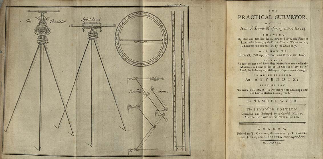
To learn—and be licensed—to be a surveyor required a combination of book learning and hands-on experience. Among the most important texts on the subject was William Leybourn’s The Compleat Surveyor: Or, The Whole Art of Surveying of Land: By a New Instrument Lately Invented; as Also by the Plain Table, Circumferentor, the Theodolite as Now Improv'd, Or by the Chain Only (“Circumferentor” is a technical turn for “surveyor’s compass”). Leybourn’s text was first published in 1653, and while it wasn’t the first book on the subject of surveying, it was the first surveying manual that didn’t offer a justification for the practice.[1] Later authors like Samuel Wyld sought to find their own niches, reporting on newer practices or providing more “practical” guides like Wyld does in The Practical Surveyor, which is currently on display (I tend to think of the “practical” guides as the 18th century version of “The Dummies Guide to X” series). One of my favorites in the APS collection, the 8th edition of Robert Gibson’s A Treatise of practical surveying; which is demonstrated from its first principles: Wherein everything that is useful and curious in that art, is fully considered & explained from 1798, notes that his guide is specifically for surveying in the United States. Despite the proliferation of surveying texts, Leybourn remained the standard text—a 1679 copy was in George Washington’s library at the time of his death in 1799, and is also listed in Washington’s 1764 inventory of books. The 1764 inventory says that the book belonged to William Fairfax and the 1799 inventory notes Fairfax’s signature, suggesting that Washington acquired it from the very family that had first employed him in the trade.
While books could provide instructions, there was no substitute for practical experience. Washington himself first worked as an apprentice surveyor at the age of 15, carrying chains and learning to use a compass. By the age of 17, he was working as a professional surveyor—one of his earliest surveys is on display in the exhibition (part of the Sol Feinstone Collection from the David Library of the American Revolution)—and though he only spent a few years working as a professional surveyor before he inherited Mount Vernon, he continued to produce surveys throughout his life. In fact, on the day before his death, his step-grandson noted that Washington was at work at Mount Vernon and “As was usual with him, he carried his own compass, noted his observations, and marked out the ground.” Washington was not the only surveyor among the Founding Fathers and understanding the lay of the land and its distribution was extremely valuable for those who wanted to advance in colonial society.
Who could be a surveyor in the 18th century?
It’s important to know that in the 18th century, surveying was a profession that was primarily restricted to men, and, at least professionally, to white men. It would have required time, money, training, and some kind of patronage or political connection to be licensed as a surveyor, and few outside of the middle and upper classes would have had the resources to obtain a position. Nonetheless, surveying parties were routinely described as being like small armies, and there are numerous examples of Native and black men who were involved in the work of surveying and mapmaking, even when their work went uncredited in the final product.
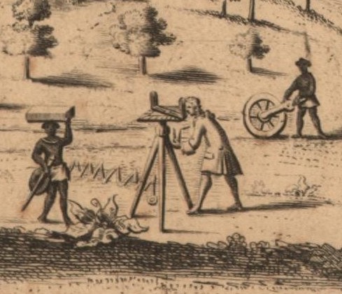
Early examples documenting Native and black men involved in the work of surveying can be found in William Byrd II’s History of the Dividing Line Betwixt Virginia and North Carolina, an early manuscript draft of which is on display in Mapping a Nation. In his description, Byrd describes his party as including three enslaved men and three members of the Tuscarora nation, and while it is clear that the party relied on their labor and guidance throughout the expedition, he provides little detail about what precisely they did. The cartouche of William Mayo’s 1722 New & Exact MAP OF THE ISLAND OF BARBADOES IN AMERICA: According to an Actual & Accurate Survey Made in the Years 1717 to 1721 provides a valuable image of the surveyor at work (possibly Mayo himself, who was the chief surveyor on Byrd’s expedition 1728), and includes two black men who were likely enslaved. While the surveyor uses a plane table, one of the men uses a surveyor’s wheel (also known as a waywiser, perambulator, or hodometer) and the other carries a Jacob’s staff (on which an instrument could be mounted for stability), a box, and an unidentified round object. Between the surveyor and the second man is a stylized Gunter’s chain. Historians of mapping believe that Mayo included himself in the cartouche, so it seems highly likely that the two men he included in the image were the men who assisted him in the survey.
Much later, in 1791, Benjamin Banneker, a free black astronomer and mathematician, joined the surveying party tasked with laying out Washington, D.C. Hired by Andrew Ellicott, who had been able to use his skill as a surveyor and political and scientific connections to advance his career, Banneker joined the party for just three months. Silvio Bedini, a historian of early American science, includes in his book, The Life of Benjamin Banneker, that Banneker was paid less than the other men involved in the survey, and slept and took his meals separately from them as well. Nonetheless, after Banneker corresponded with Jefferson—becoming the first black man known to have directly challenged Jefferson about his racist views—and shared a draft of his first almanac, Jefferson would claim to the Marquis de Condorcet that he had been the one to recommend Ellicott hire Banneker for the survey of the federal city (a lie). Only Ellicott’s name appeared on the final product of the survey, the plan of Washington, D.C., which includes a description about the work of the surveyor(s). Nonetheless, Banneker achieved fame during his lifetime because of his almanacs. Later, after Banneker’s death, Jefferson would spread the rumor that Banneker’s work had been done by Ellicott.
Native knowledge and labor was more likely to be acknowledged on maps of North America because it gave greater weight to claims about certain geographies to be able to point to a source that knew the region, though it was still often uncredited. Lewis Evans’s maps of Pennsylvania and the neighboring colonies from 1749 and 1755 clearly note the presence of different Native nations (and implicitly acknowledges their territorial claims), and are especially valuable in that Evans’s own writing records his reliance on Native informants and guides to understand Pennsylvania’s geography. Evans was not alone in relying on Native knowledge to understand North America’s geography, however, and the two most extraordinary objects in Mapping a Nation reflect the contributions of Native mapmakers. These maps, one drawn in chalk by the Lenape negotiator Teedyuscung at the Treaty of Easton and the other drawn in the sand by “The Great Chief and one of the Chim-nâpum Nation,” were both copied onto paper by white men, and their original impermanence reveals one reason there are so few Native-made maps from the 18th century in archives, beyond the fact that those archives have historically made a priority of keeping records made primarily by white men.
Surveying was a profitable profession that could serve as a path to other types of political positions and at various points, complaints arose that anyone with a compass could set themselves up as a surveyor in places where licensing was less stringent. It’s important to remember, nonetheless, that rarely was the complete picture of the labor it took to produce a survey or map actually conveyed by the final product and that those most likely to be excluded from that picture were those marginalized by society more broadly: people of color, the poor, and women.
To be continued...
Check in next week for part two with more about clocks, compasses, chains, and other tools of the trade.
[1] Andrew McRae, “To Know One's Own: Estate Surveying and the Representation of the Land in Early Modern England.” Huntington Library Quarterly, Vol. 56, No. 4 (Autumn, 1993), pp. 333-357.