A Few Technical Items: Questions About 18th Century Surveying Instruments Answered (Part II)

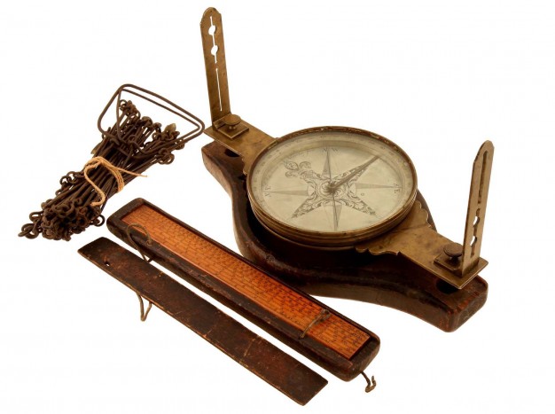
Top image: Surveyor's Instruments, c. 1765 APS.
This post is part two in Erin Holmes's series "A Few Technical Items: Questions about 18th Century Surveying Instruments Answered." Read part one for more on who became surveyors in the 18th century and how they trained. Today's post explores the various instruments they used in their work, many of which are on display in Mapping a Nation.
Why would a surveyor need a clock?
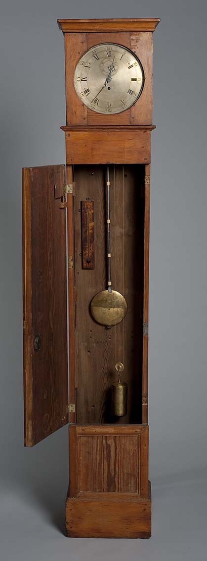
David Rittenhouse is probably one of the most important Early Americans that most people know little or nothing about. Born in Pennsylvania and sickly throughout his life, he was nonetheless considered one of North America’s leading scientists in the 18th century. He is especially known for his work as an astronomer and instrument maker, two skill sets that equipped him well to take on the work of a surveyor. In 1769 he created a number of instruments—including an “astronomical clock”—to help him document the Transit of Venus, a planetary eclipse that sparked an international effort to obtain precise measurements of the event from a number of different locations around the globe. With these measurements, it would be possible to calculate the distance between Earth and the Sun, and, in turn, the size of the universe. The effort to measure the Transit was hugely successful, and put the APS on the map when they were able to publish their results years before any of the Royal scientific societies in Europe.
In 1784, Rittenhouse joined a party of surveyors tasked with extending the Mason-Dixon Line. The original party led by Charles Mason and Jeremiah Dixon in 1768 had stopped at what is now Dunkard Creek, PA when their Haudenosaunee guides reached the boundary of their territory and that of the Lenape, with whom they were engaged in hostilities. Nearly two decades later, with the American Revolution recently concluded, it was important to clearly establish the boundaries between the states, so Rittenhouse joined the party to establish Pennsylvania’s southern boundary—and brought along his portable field clock, which likely required a cart and at least two other people.
Rittenhouse would first use the clock in combination with a magnetic compass to establish solar noon, when the sun crossed the celestial meridian (an imaginary line running due South to due North). He would then compare the difference in time between that place and a place whose solar time and longitude were already known (surveyors could use a chronometer, a specialized time piece that gave the time in a particular known location, or use published tables that gave position of the moon among the stars at specific times in a particular place, like Greenwich, England, and compare the difference in the moon’s location), which made it possible to calculate the exact degree of longitude. With longitude established, Rittenhouse then recorded the angles stars made as they passed that specific line of longitude, called the meridian, allowing him to precisely establish the latitude of his position. Together, these coordinates allowed Rittenhouse and the surveying party to mark the boundary between Pennsylvania and Maryland along the correct line of latitude.
How did surveyors use a Gunter’s chain? (Also, what is a Gunter’s chain?)
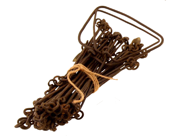
Mathematician Edmund Gunter invented the chain that bears his name in 1620. Around the same time, Aaron Rathbone attempted to introduce his own version of the chain, but Gunter’s proved more versatile (Rathbone’s chain supposedly had a designated front end and back end and could only be used in one direction). Gunter’s chain sought to reconcile traditional English land measurements, based on the number 4, with the decimal system. Each chain was composed of 100 links, measuring 66 feet total (each link measures 7.92 inches long). A chain is subdivided into four parts—each made up of 25 links measuring 5 ½ yards, or 16 ½ feet—called “rods,” “perches,” or “poles.” These quarter intervals are marked on the iron or steel chain by brass tags.
Before using a Gunter’s chain, the surveyor would walk the boundaries of a property and identify corners and significant landmarks—often trees or large rocks. With the chainmen, the surveyor would then identify the starting and ending points of a particular line. The two chain carriers would take hold of either end while the surveyor used a compass or theodolite to mark the distance along a particular line of latitude. As they moved along, the leader marked the ground with an “arrow,” or metal pin, and the follower walked in that direction. Upon reaching the leader, the follower picked up the “arrow” and replaced it with a wooden stave. Together, they would determine if their line was straight, and if not, with the help of the surveyor, they would adjust it before moving forward. When the leader was less than one chain’s length away from the final point, the chain carriers would stop and count the links between the last stave and the final station to determine the exact measurement.[1]
10 Gunter's chains=1 furlong
80 Gunter's chains=1 mile
10 square Gunter's chains=1 acre
Today, the Gunter’s chain has been replaced by a steel tape, but the measurement remains. In fact, the Public Lands Survey continues to keep measurements in chains to maintain the consistency of its records.
What is the difference between a compass and a theodolite? And what is the difference between a theodolite, an “azimuth theodolite,” and an “altazimuth theodolite”?
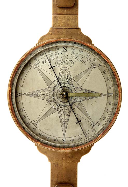
Essentially, each type of tool gives you increasingly more precise—and increasingly more kinds of—measurements. A surveyor’s compass (also known as a circumferentor) relies on a magnetized needle to determine magnetic north. It needs to be perfectly level to get a precise measurement, so a small bubble level can be found on most 18th century compasses. Because magnetic compasses use magnetic north to establish their position, their measurements can change over time. Vernier compasses use a variation arc and vernier mechanism to account for the difference between true or geographic north and magnetic north. They originated in the United States—the first known example was made by David Rittenhouse, probably sometime in the 1780s, and his brother, Benjamin Rittenhouse, made a number of them—and by the end of the 18th century, vernier compasses were widely used by professional surveyors.
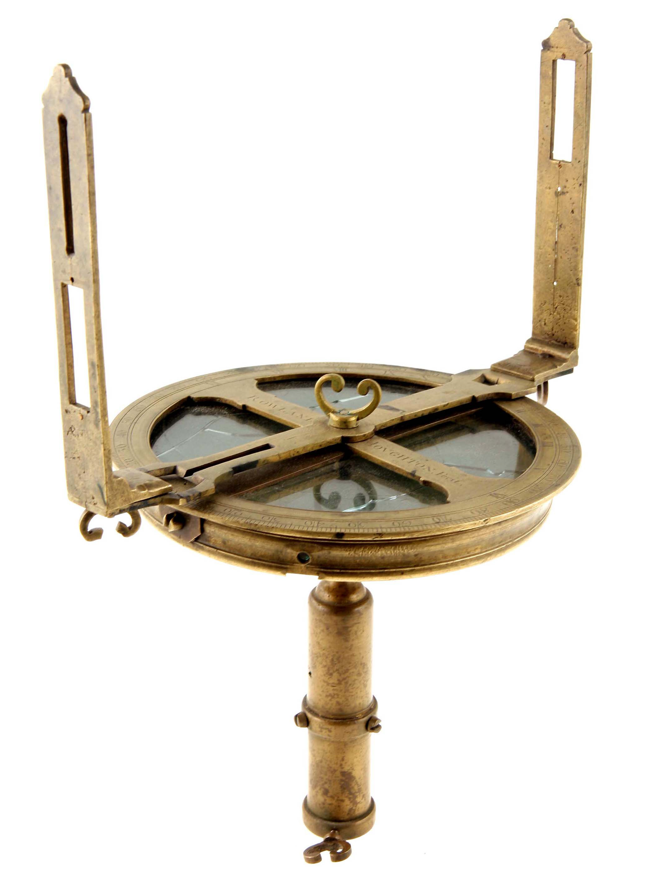
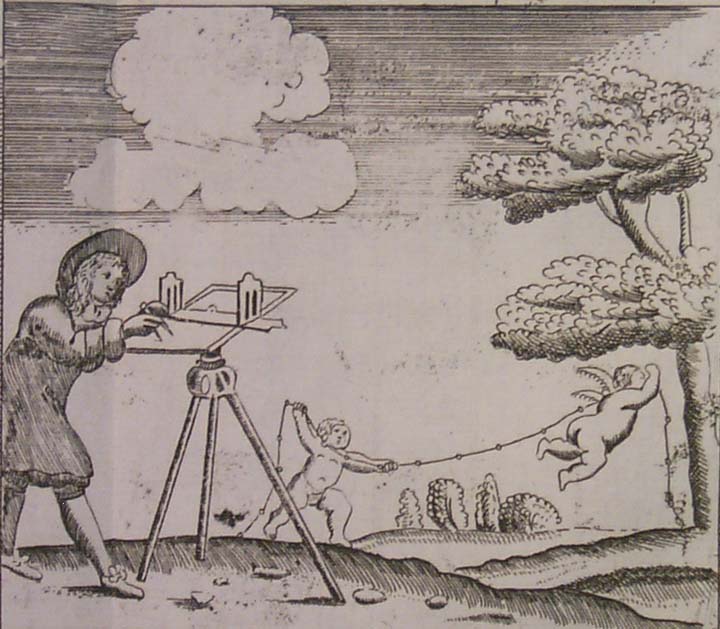
Theodolites have existed in one form or another since the 16th century. A common theodolite (like the example made by Rowland Houghton) has a surveyor’s compass (also known as a circumferentor) at its center surrounded by a larger graduated ring (usually made of brass). Two sight vanes are attached to the circumferentor, while the graduated ring often (but not always) has two additional sight vanes, for a total of four sight vanes. This “common” theodolite can also be called an “azimuth” theodolite, describing the kinds of angles that it measures—horizontal angles, or azimuths. An “altazimuth theodolite,” would have been preferred when working with large changes in elevation, since its telescope (and additional graduated arc) would allow the surveyor to measure altitudes in addition to azimuths, i.e. both vertical and horizontal angles.
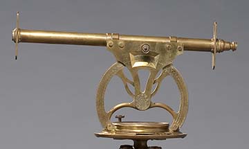
Altazimuth theodolites like the one made by Thomas Heath on display in Mapping a Nation developed sometime during the 17th century and initially relied on line of sight (focused using an alidade) to establish the distant point. In 1725, Jonathan Sisson, one of England’s foremost instrument makers, replaced the open-sight alidade with a sighting telescope to create the modern theodolite. Other instrument makers continued to make adjustments, and by the end of the 18th century, most European surveyors used some kind of theodolite to do their work. In North America, however, the surveyor’s compass or circumferentor remained the preferred instrument, as it was better suited to dealing with forested terrain.
[1] Directions paraphrased from Samuel Wyld’s The Practical Surveyor (first edition, 1725).