
Cross country in 1804-1806
 |
| A selection of the journals of Lewis and Clark |
When Thomas Jefferson acceded to the Presidency in 1801, one of his great unfulfilled wishes was to see a proper scientific expedition carried overland to the Pacific. As a Congressman in 1783, he had failed to convince George Rogers Clark to explore the west, and in 1793, his plans for
André Michaux fell prey to international political machinations, and several other attempts had failed at even earlier stages. But in 1801, Jefferson dusted off the basic plan he had devised for Michaux, and once again, prepared to send an exploring party to the west.
To lead his expedition, Jefferson tabbed his personal secretary, Meriwether Lewis, a political ally, fellow Virginian, and a rejected applicant (at the tender age of 19) for the Michaux expedition. Lewis was not the worldly savant that Jefferson was, but he was well-read, wrote occasionally beautiful prose, was scientifically versed, and experienced in wilderness life. Lewis was allowed to select his second in command, an old army friend, William Clark, with whom he had served in the Northwest Territory. Although less well-educated than Lewis, Clark was an astute observer in his own right and if his prose was less polished, he was a more conscientious diarist and a very capable cartographer. Differing in personality, the moody Lewis and solid Clark made a compatible team.
From the outset, the Lewis and Clark expedition seemed destined to enjoy a better fate than its predecessors. While Michaux had become ensnared in international rivalries after entering the field, Lewis and Clark were presented with news that the Louisiana Territory had been purchased, removing one more international hurdle to clear in an already arduous course. Although usually thought of as a scientific expedition, it was driven as much by political and commercial interests as scientific. In keeping with his Enlightened precepts, the information that Jefferson hoped to gain was practical as well as theoretical. He hoped as much to spur the extension of the fur trade further into the interior as to advance pure knowledge, and wished to determine which areas were most amenable to white settlement. On the political front, Lewis and Clark were specifically enjoined to cultivate alliances among the Indians to blunt Spanish and British influence in the region. Above all, the success of the expedition promised to aid in fulfilling what Americans thought was inevitable: extending American sovereignty from sea to sea.
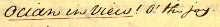 |
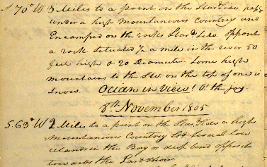
Entry for Nov. 7, 1805, upon first view of the ocean
(actually the Columbia Estuary) |
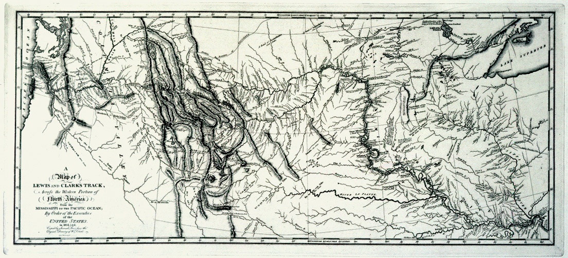
Lewis left Philadelphia in the summer of 1803, and picked up Clark and a few recruits in Indiana before arriving late in the year at the staging area near St. Louis. After making final preparations, they set off on May 14, 1804, for the west, ascending the Mississippi to the mouth of the Missouri, and then westward. From North Dakota to nearly the coast, Lewis and Clark passed through lands that no Europeans had ever seen, before reaching their goal, the Pacific, in November, 1805. On the return leg of their journey (begun on March 3, 1806), the two improvised an even more ambitious plan, splitting their party in two to cover more territory, before rejoining in North Dakota. Their arrival in St. Louis was on September 23, 1806.
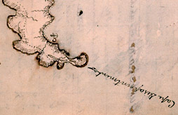 |
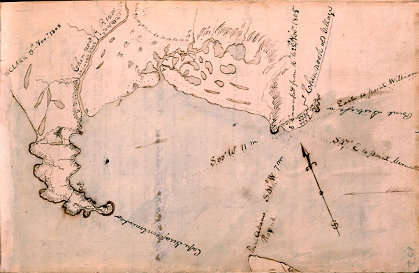
| William Clark's map of Cape Disappointment, Nov. 1805 |
Today, all along
the original trail, the expedition is remembered as an example of fortitude and scientific achievement. Unlike many who followed, the explorers were cooperative with the native peoples they encountered - indeed, they were reliant upon them - and on only one occasion did they resort to violence. In their descriptions of dozens of new plant and animal species, in their lengthy "ethnographic" descriptions of Native Americans, and in their invaluable maps of the region, Lewis and Clark more than justified Jefferson's confidence and truly set the stage for an American west.
A glimpse of the journals
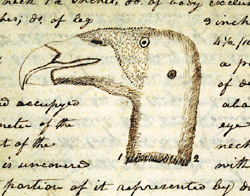 |
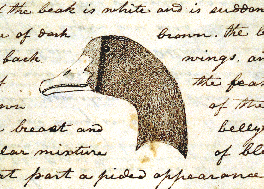
| Lewis' 'vulture' (California condor) |
For archivists, journals are seldom what they appear. For years, a controversy surrounded the journals of Lewis and Clark, which seemed far too polished to be field notes taken on one of the most arduous expeditions ever undertaken on American soil. The difficulties of the journey, combined with the existence of other, overlapping journals in Clark's hand (now at Missouri Historical Society), seemed to suggest that the journals at the APS might be the product of post-expedition copying, rather than the "originals." How could the leaders of forty some soldiers take
time each day to write such lengthy descriptions of what they saw, and how could they keep these beautifully bound volumes so clean? Was it possible that these notebooks were influenced by the sometimes-faulty memories of the explorers long after the events they describe?
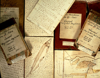
The Lewis and Clark journals at the APS consist of eighteen small notebooks, approximately 4x6 inches, of the type commonly used by surveyors in field work. Thirteen of these are bound in red morocco leather, four in boards covered in marbled-paper, and one in plain brown leather, and there are a number of loose pages and rough notes as well. Some previous editors of the journals argued that the excellent condition of the journals indicates that they were fair copies made after the end of the expedition in September, 1806, and prior to Jefferson's receiving them at the end of the year. Others, however, suggest that the story is more complex.
The available evidence suggests that Lewis and Clark carried their notebooks sealed in tin boxes that were intended to protect the relatively fragile journals from the elements. If nothing else, with Jefferson's advising, the journals were considered invaluable as the only reliable record of data gathered on the expedition. It seems likely, therefore, that great care would be taken in their preservation. From a close examination of the journals and sets of loose notes, Gary Moulton, among others, has concluded that Lewis and Clark often worked from rough notes compiled daily, then periodically transcribed these into more polished form in the bound volumes, however in most cases, the time between taking the notes and transcribing them must have been very brief. On many occasions, the explorers clearly wrote directly into the bound volumes.
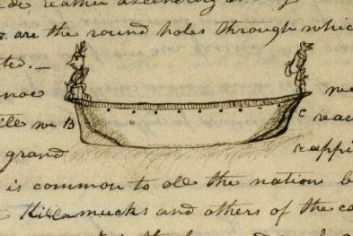
The journals contain huge volumes of data, going beyond geographical notes and records of temperature and weather. Both men made meticulous observations on the geology and biology of the region and enlivened their journals with images of animals and plants, Indian artifacts, canoes, and costumes. Clark drew a number of splendid maps.
In 1999, conservation of the Lewis and Clark journals was made possible through a generous grant from the Pew Foundation.
| Currently on exhibit |
|---|
Book of hours, 15th century
Charter of Privileges, 1701
The Declarations of Independence, 1776
Ben Franklin's jottings, 1783
Louis XVI miniature portrait, 1784
John Cram's fan chair, 1786
Michaux subscription list, 1793
Jefferson's vocabulary, 1802-1808
Lewis and Clark journals, 1803-1806
Peale's mastodon, 1821
|
|
©2006 American Philosophical Society
