Realms of Gold: A Catalogue of Maps in the Library of the American Philosophical Society
Images from Printed Maps
Part 1. - Space, the World, and the Antarctic
|
 |
|
|
|
|
|
|
|
|
|
|
|
|
|
|
|
|
|
Space
|
|
|
|
|
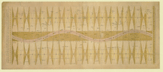
53.
A chart of the zodiacal stars, used in finding the longitude at sea by the moon. And their hourly positions to the circumpolar
stars, both above and below the north and south poles. By S. Dunn. London.
Cartographer:
S. Dunn.
|
4 July 1772. |
Size of paper: 38.1 x 90.1 cm.
Colored.
|
(523.29: 1772 Large) |
|
Provenance:
Presented by Samuel Dunn, 8 October 1772.
|
|
|
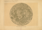
54.
[Map of the moon accompanied by an explanation of the figures and letters]. N.p.: [ca.1832].
Cartographer:
J. J. Littrow and Albert Richard.
|
[ca.1832]. |
Size: 40 cm. diameter.
|
(022: [ca.1832]: L722mar Large) |
|
Enclosed in original wrapper marked: DERMOND.
Provenance:
Presented by C. Nagy, 15 May 1833.
|
|
|
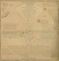
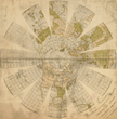
55.
Sketch of the solar system for the use of schools. Printed at the Lith. Press of His Majesty the King of Oude. Lucknow: 1835.
|
1835. |
Size: 75.2 x 73.9 cm.
|
(523.2: Sk2s Large) |
|
Provenance:
Presented by J. P. Engles.
|
|
|
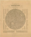
56.
General-Karte der sichtbaren Seite der Mondoberflaeche zugleich als übersichts-Blatt zur grössern Mondkarte von Wilh. Beer
und Joh. Heinr. Mädler. Berlin: Simon Schropp et Comp.: 1837.
Cartographer:
Wilh. Beer and Joh. Heinr. Mädler.
Engraver:
E. Leidenfrost.
|
1837. |
Size of paper: 59 x 48.3 cm.
|
(022: 1837: B397gks Small) |
|
Provenance:
Presented by A. D. Bache, 6 December 1839.
|
|
|
The World
|
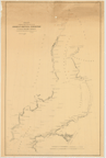
|
|
|
|
65.
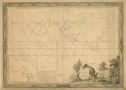
Carte des parties principales du globe terrestre pour servir à l'histoire des deux premiers siècles depuis la création du
monde. Dediée à Monseig[neu]r le Comte de Saint Florentin, ministre & secrétaire d'état, Commandeur des Ordres du Roy. Par
Monsieur Luneau de Boisjermain. Paris: 1765.
Cartographer:
H. Gravelot.
Engraver:
Jac. Charpentier.
|
1765. |
Size: 59.8 x 82.3 cm.
|
(100: 1765: L965ter Large) |
|
Inset: Supplement à la carte du Paradis Terrestre.
"Premier feuille."
|
|
|
66.
Chart of the world, according to Mercator's projection, shewing the latest discoveries of Capt. Cook. London: C. Dilly and G. Robinson: 1785. 15 June 1785.
|
15 June 1785. |
Size: 37.2 x 48.6 cm.
Colored.
|
(100: 1785: D582mer Large) |
|
Engraved for Guthrie's new system of geography.
Contains manuscript notations for use in Carey's edition. The Transactions (Vol. 6) state that Carey presented the "Materials from which Guthrie's Geography were compiled." This is one of those maps.
See: William Guthrie, The general atlas for Carey's edition of his geography improved. Philadelphia: Carey: 1795 [1 May 1795] (912.G98c).
Provenance:
Presented by Mathew Carey, 18 October 1805.
|
|
|
74.
To George Washington president of the United States of America this magnetic atlas or variation chart is humbly inscribed
by John Churchman. Philadelphia: James Johnson: 1790. First edition. Trimmed.
Cartographer:
John Churchman.
|
1790. |
Size of paper: 60.6 x 62.4 cm.
Colored.
|
(100: 1790: C492mag Large) |
|
In: Pam. 538.7:C47e. John Churchman, An explanation of the magnetic atlas or variation chart. Philadelphia: James Johnson: 1790. Front.
Churchman was an American who was devoted to his own theories of the variations of the magnetic needle and other things. He
had presented his scheme to the Society in 1787 and was given mild encouragement. He founded his belief on the
hypothesis of two bodies (besides the moon) revolving round the earth, in small circles parallel to the equator; one near
the north pole, and the other was near the south pole; and the needle, being wholly governed by the attraction of these magnetic
satellites, will, in whatever part of the world, always rest in the plane of the circle, passing through them and the given
place. [The American Museum, Sept. 1789: p. 218].
He persevered in his work and at the 17 September 1790 meeting his "Navigation Chart, or Magnetick Atlas" was presented. It
disappeared, but another copy was given by Johann Rodolph Valltravers on 19 May 1797. The Valltravers copy is the one now
at the Society.
Wheat: 6
Provenance:
Presented by the author to the Society, 17 September 1790, with a description. Another copy presented by Johann R.
Valltravers, 19 May 1797.
|
|
|
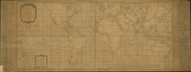
77.
A correct chart of the terraqueous globe, on which are described lines shewing the variation of the magnetic needle in the
most frequented seas; originally composed in the year 1700 by the celebrated Dr. Edmund Halley; renewed by William Mountaine
and James Dodson, F R S according to observations made about the year 1756. London: Laurie & Whittle: 1794 [12 May 1794].
Cartographer:
Edmund Halley, William Mountaine, and James Dodson.
|
12 May 1794. |
Size: 52.1 x 122 cm.
Size of paper: 55.3 x 147.9 cm.
|
(100: 1794: M865haL Large) |
|
On either side are: An account of the variation chart, and, Remarks on the variation lines &c.
|
|
|
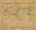
81.
A new and authentic map of the world embracing all the recent discoveries, and exhibiting particularly the nautical researches
of the most distinguished circumnavigators from the latest & best authorities with numerous corrections & additions, by H.
S. Tanner, 1831. Philadelphia: Tanner: 1831.
Cartographer:
H. S. Tanner.
Engraver:
E. B. Dawson.
|
1831. |
Size: 89.8 x 168.5 cm.
Colored.
|
(100: 1831: T158wnr Large) |
|
Contains also: comparative lengths of the principal canals in the world, projected on a scale of 34 miles to an inch; statistics
for North America, South America, West Indies; Summary of Africa, Asia, Oceania, and Europe statistics; heights of mountains;
British possessions in Africa, America, Asia, Oceania; possessions of European powers in Asia, Oceania, Africa, America; vertical
sections of North America, projected on uniform scales.
Provenance:
Presented by Henry Schenck Tanner, 15 April 1831.
|
|
|
The Arctic
|
|
|
|
|
94.
Chart exhibiting the discoveries of the Second American Grinnell Expedition in search of Sir John Franklin. Unrevised from
the original material and projected on the spot. E. K. Kane. Deposited 15 November 1855.
Cartographer:
E. K. Kane.
Engraver:
Julius Bien.
|
15 November 1855. |
Scale: 2.8 cm. = 10 mi.
Size: 89 x 56.2 cm.
|
(172.3: 1855: G895exp Large) |
|
Provenance:
Presented by E. K. Kane.
|
|
|
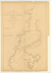
96.
Chart showing the discoveries tracks and surveys of the Arctic Exploring Expedition of 1860 and 1861. I. I. Hayes, M.D., commanding. Newly projected from revised materials discussed for the Smithsonian Institution by Charles A. Schott. Washington: 1865.
Cartographer:
Charles A. Schott.
Engraver:
H. S. Barnard and A. Petersen.
|
1865. |
Scale: 1:1,200,000.
Size: 57.8 x 36.2 cm.
|
(171: 1865: Sch67aee Small) |
|
|
|
|
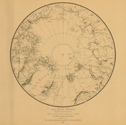
97.
The Arctic regions comprising the most recent explorations of Robert E. Peary, Fridtjov Nansen, and F. Jackson, by Prof. Angelo
Heilprin. Philadelphia: Geographical Society of Philadelphia: 1897.
Cartographer:
Angelo Heilprin and J. W. Ross.
|
1897. |
Size of page: 45 x 49.5 cm.
|
(170: 1897: H343pnj Small) |
|
|
|